
Why are we doing this project?
Summary
We are presenting this proposal now to be done by our team (“see Team”) and in the area south of Lake Yaxhá. We believe that we can have a real impact with this project for academic and non-academic objectives. We aim to expand the reach of remote sensing surveys in a cost-effective way outside of the core areas. On the other hand, for public engagement and the development of the area through the promotion of the Maya history and the understanding of the people that live in the area nowadays, creating a bridge between external researchers and local people.
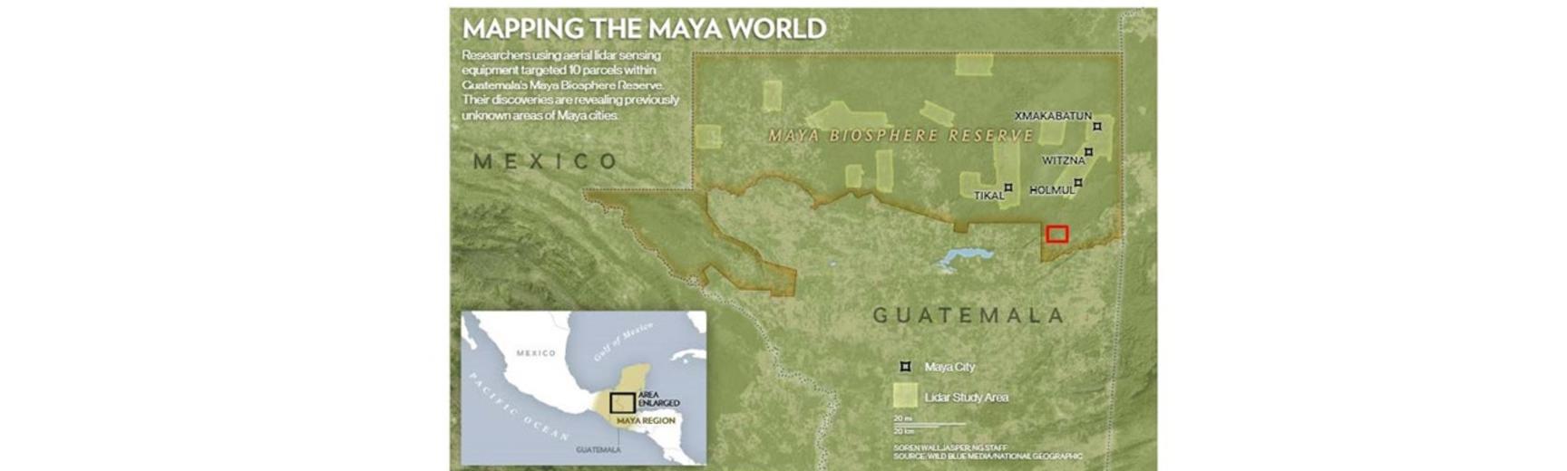
Image Caption: Map of the Maya Biosphere Reserve in Guatemala, with a red square marking the area of Lake Yaxhá.
Credits: Source Wild Blue Media /Natural Geographic through Clynes 2018.
Edited by: Cristina Gonzalez-Esteban.
The usage of LiDAR technology in the Maya Area
Remote sensing, and specifically LiDAR, have become very resourceful tools to identify and record areas of archaeological interest in the Mesoamerican forested region, as it can be in the projects done at sites in Belize (e.g. Caracol, Cayo, El Pilar), Mexico (e.g. Angamuco, Michoacán) (Chase et al. 2012), Guatemala (e.g. PACUNAM project -Clynes 2018-, San Bartolo -Griffin 2020-, Yaxhá -Quantum Systems and Universidad de Jaen 2022-) or Honduras (e.g. Copan –von Schwerin et al. 2016).
However, most of these studies have been done at large-scale sites, focusing mainly on their central core areas, and neglecting to study the surrounding areas which often contain highly relevant satellite sites. These omissions are largely due to economic and administrative pressures primarily affecting smaller sites, inter-site areas or landscapes, and places with smaller budgets, all of which could greatly improve our understanding of the Maya culture, often being overlooked.
This shifts the understanding of the culture towards those higher Maya hierarchies which had the capabilities to build the most visually evident remains. The importance of these neglected areas has been recently highlighted at the Maya site of Yaxhá this past 2022 summer, where the Quantum Systems LiDAR survey demonstrated the number of unexplored remains in the intersite area of the National Park of Yaxhá-Nakum-Naranjo and the large potential of this remote sensing technology as a first point of reference to identify them under the canopy.
Therefore, this project aims to test different types of LiDAR and data collection (terrain and airborne) to achieve a balance between cost and quality. The chosen area has been the clustered sites south of the mentioned Lake Yaxhá. They were picked from the Guatemalan Northern Lowlands, also called Maya Biosphere Reserve, which was highly inhabited by the Maya; but still outside of the PACUNAM study areas (largest archaeological LiDAR project in Guatemala) in order to pick sites “understudied”. Other factors that influenced this decision were the distance between each other (as our project has limited time), the possibility of easily developing inter-site survey, their accessibility by road, and their lack of a detailed digital survey.
A multidisciplinary approach
At the same time, the introduction of Artificial Intelligence will reduce the human workload when processing the data, allowing quicker acquisition of results when analysing big data. Its visual outcomes, also intend to incentive the visit of this smaller site by local and foreign tourism, reverting the benefit of our study also to the local economy.
While the primary objective of this project is to utilise new technologies for archaeological surveys, we also acknowledge the opportunity for recognizing and comparing different forms of “knowing” the land: (1) hand-drawn maps made by archaeologists in the 1970’s, as redrawn from the 1930’s maps (2) the modern technologies of LiDAR and computer learning, and (3) local knowledge and folklore. Simultaneously, we can use this ethnographic research to reflexively examine the impacts of external research expeditions on local communities.
References
Chase, A. F., Chase, D. Z., Fisher, C. T., Leisz, S. J., and Weishampel, J. F., 2012. Geospatial revolution and remote sensing LiDAR in Mesoamerican archaeology. In Jeremy A. Sabloff (ed.) Proceedings of the National Academy of Sciences, 109 (32): 12916-12921.
Clynes, T., 2018. Exclusive: laser scans reveal Maya “megalopolis” below Guatemalan jungle. National Geographic, 1
Griffin, R., 2020. Using LiDAR to Map Ancient Maya Urban and Agricultural Patterns in San Bartolo Guatemala. RCEU Project Proposals, 112. https://louis.uah.edu/rceuproposals/112
PACUNAM, n.d. [online] https://pacunam.org/ Accessed 20/01/2023
Quantum Systems, 2022 [online] https://www.quantum-systems.com/ Accessed 15/11/2022
von Schwerin, J., Richards-Rissetto, H., Remondino, F., Grazia Spera, M., Auer, M., Billen, N., Loos, L., Stelson, L., and Reindel, M., 2016. Airborne LiDAR acquisition, post-processing and accuracy-checking for a 3D WebGIS of Copan, Honduras. Journal of Archaeological Science: Reports, 5: 85-104. https://doi.org/10.1016/j.jasrep.2015.11.005